
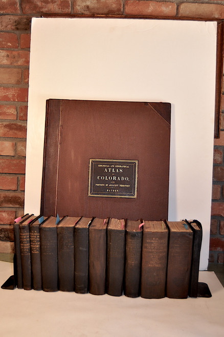


Hayden, Ferdinand V.; United States Geological and Geographical Survey of the Territories, 1st through 12th Annual Reports with Atlases. Washington, GPO 1870-1878. Octavo text volumes, octavo atlas, large folio Colorado atlas.
The set is complete with all maps, plates and text figures present. All of the volumes and the octavo size atlas are in the original brown cloth. The bindings have light wear, the spine titles are faded on most volumes. Three reports have a cancelled library stamp, one report has a private owners stamp on an end sheet. The other reports are free of ownership markings. Three reports have been re-cased and have later end sheets. The plates and maps in the reports are clean and bright. The maps in the octavo size atlas to the 12th Annual report have been re-backed with archival tissue and are well preserved. The folio atlas is in the original half calf and cloth with the gilt title label. The binding was re-cased at some point and is tight and clean with the maps very clean and bright. There is a light wrinkle to the cloth on the front board. Overall a very good complete set.
The pagination follows:
First, Second and Third Annual Report of the United States Geological Survey of the Territories for the Years 1867, 1868 and 1869. Washington, GPO 1873. Octavo, pp. 261. (Reprinted from Report of the General Land Office). The third report contains Frazier’s Mines and Minerals of Colorado and New Mexico.
Fourth Annual. Preliminary Report of the United States Geological Survey of Wyoming and Portions of Contiguous Territories… Washington, GPO 1871. (Though called in the title a second annual report, this is actually the 4th since the informal 1st through 3rd reports of 1867-1869 are considered annual reports. Octavo, pp. 511.
Fifth Annual. Preliminary Report of the United States Geological Survey of Montana and Portions of Contiguous Territories… Washington, GPO 1872.
Octavo, pp. vi, 538 with 5 maps and 2 plates present.
Sixth Annual Report of the United States Geological Survey, Embracing Portions of Montana, Idaho, Wyoming and Utah… Washington, GPO 1873.
Octavo, pp. xi, 844 with 5 maps and 12 plates present.
Seventh Annual Report of the United States Geological and Geographical Survey, Embracing Colorado… Washington, GPO 1874.
Octavo, pp. xii, 718 with 54 maps and plates present.
Eighth Annual Report of the United States Geological and Geographical Survey, Embracing Colorado and Parts of Adjacent Territories… Washington, GPO 1876.
Octavo, pp. ix, 515 with 82 leaves containing plates and illustrations.
Ninth Annual Report of the United States Geological and Geographical Survey, Embracing Colorado and Parts of Adjacent Territories… Washington, GPO 1877.
Octavo, pp. vii, 827 with 75 maps and plates present.
Tenth Annual Report of the United States Geological and Geographical Survey, Embracing Colorado and Parts of Adjacent Territories… Washington, GPO 1878.
Octavo, pp. xxix, 546 with 3 maps and 75 plates present.
Eleventh Annual Report of the United States Geological and Geographical Survey, Embracing Idaho and Wyoming… Washington, GPO 1879.
Octavo, pp. xxviii, 720 with 89 maps and plates present.
Twelfth Annual Report of the United States Geological and Geographical Survey, A Report on the Progress of the Exploration of Wyoming and Idaho…In Two Parts with folio of maps. Washington, GPO 1883.
Octavo, Part 1, pp. xviii, 809 with 155 maps and plates present. Part 2, pp. xxv, 503, with 151 maps and plates present. Map case containing 10 folded maps.
Folio Atlas, United States Geological and Geographical Survey of the Territories. Geological and Geographical Atlas of Colorado and Portions of Adjacent Territory. Julius Bien Lith. 1877.
Elephant folio, pp. 2, 20 double folio atlas sheets measuring 37 x 26.5 inches.
Included are: a triangulation map, drainage map, economic map (colored), and geological map (colored) covering the entire State and adjacent portions of Utah, Arizona, and New Mexico at a scale of 12 miles to one inch; six topographical and six colored geological sheets, covering the region at 4 miles to the inch; two colored sheets of geological sections; and two sheets of panoramic views.
Ferdinand V. Hayden ( 1829-1887) was an American geologist who made major contributions to the early studies of the western territories of the United States. His explorations and geologic studies of the Great Plains and Rocky Mountains laid the foundation of the original U.S. Geological Survey.
In 1853 Hayden’s first exploration was with the paleontologist Fielding B. Meek to the Dakota Badlands to collect fossils. The discoveries led to Hayden’s series of scientific explorations over subsequent years which became. the “Hayden Surveys”. The surveys launched the careers of numerous American scientists and the maps and published volumes provided valuable scientific data on the geology, paleontology, botany, and zoology of the West. The surveys not only collected fossils but made the first attempts to determine stratigraphic sequences in rock formations, and studied uplift, folding, faulting, and other geologic processes evident in the Rockies.
Hayden also played a leading role in the creation of Yellowstone National Park, which he had explored. His study of Yellowstone was thorough and his descriptions, paintings, maps and photographs led to the founding of Yellowstone National park in 1872.
Hayden’s expeditions also surveyed nearly all of Colorado, producing accurate maps and his famous Atlas of Colorado. The collection of fossils for scientific study was of major importance. Hayden climbed and named many of the mountains and named several rivers and geological formations. World-renowned artist Thomas Moran accompanied him, as did the photographer William H. Jackson, who took the first images of the Mount of the Holy Cross and the Mesa Verde cliff dwellings.
When the territorial surveys were consolidated into the U.S. Geological Survey in 1879, Hayden continued his studies for the USGS until his retirement in 1886.
FOR OVERSEAS PURCHASE PLEASE REQUEST A SHIPPING QUOTE.

; Profiles, Sections and Other Illustrations, Designed to Accompany the Final Report of the Chief Geologist of the Survey....1872")
![Owen, David Dale; Report of a Geological Survey of Wisconsin, Iowa, and Minnesota; and Incidentally of a Portion of Nebraska Territory. [With:] The Illustrations to the Geological Report of Wisconsin, Iowa, and Minnesota.](https://cdn11.bigcommerce.com/s-wefngua/images/stencil/500x659/products/1143/3467/OwenWisc__04783.1574354901.jpg?c=2 "Owen, David Dale; Report of a Geological Survey of Wisconsin, Iowa, and Minnesota; and Incidentally of a Portion of Nebraska Territory. [With:] The Illustrations to the Geological Report of Wisconsin, Iowa, and Minnesota.")
